


Technology advancements and increased demand for space data and analytics have been among the key enablers reshaping the industry. One prominent player riding the wave of the space revolution is EOS Data Analytics – a creator of innovative solutions at the intersection of cutting-edge technology and space.
In this article, we overview the company’s core activities and how they leverage geospatial data analysis to innovate Earth observation-based services and propel space utilisation to new heights.
Getting acquainted with EOS Data Analytics
EOS Data Analytics (EOSDA) is a global provider of geospatial data analytics, harnessing the combined power of high-res satellite images and artificial intelligence to transform a wealth of Earth observation data into actionable insights. Seeing space as a key to solving planetary challenges, the company is on a mission to provide businesses and stakeholders alike with tools for making smart data-driven decisions that eventually can shape a better future.
EOS Data Analytics operates worldwide, bringing a host of out-of-the-box and custom solutions, which cater to the needs of 20+ industries and are offered through the official website eos.com. Crystallising the team’s profound multi-year expertise in Earth sciences, GIS, and geospatial data analysis into viable products, the company aims to make every business profitable while also enabling its shift toward sustainable practices. As a pledge to its commitment to the UN’s sustainability development goals, EOSDA aligns the making of each solution with 10 of them and actively participates in environmental projects to create a positive social impact where it’s most needed.
One of the company’s flagship solutions, EOSDA Crop Monitoring, is a bright example of the application of geospatial data analysis in agriculture. With a rich suite of geospatial and agri-data available in one platform alongside a broad analytics toolset, key stakeholders get enhanced situational awareness of their crops and fields, which can further translate into increased productivity, reduced costs, and fewer environmental outcomes.
Observing Earth from space: satellite data
EOS Data Analytics specialises in processing and analysis of Earth observation data captured by diverse satellite sensors. The resulting satellite datasets vary in level of detail, frequency of observations, and spectral capabilities, so each contains unique ‘hidden’ information about the planet’s features.
To fully unlock it, EOS Data Analytics utilises powerful Cloud computing, the latest AI and machine learning technologies, and crafts proprietary algorithms with an aim to deliver maximum value in every use case. Satellite-derived insights offered by the company become instrumental in crop and forest monitoring, detecting changes in land cover/land use change detection, or environmental analysis, to name a few.
EOSDA LandViewer was the first product that entered the geospatial data analytics market under the EOSDA brand. Among the company’s offerings, this one hosts by far the broadest range of satellite imagery available for visualisation, processing, analysis, and download on the fly. In a nutshell, it simplifies access to the most sought-after public data (Landsat, Sentinel, etc.) while also offering high-resolution paid imagery (KOMPSAT, Gaofen, TripleSat, etc.). Considering the diversity of available Earth observation datasets and features for retrieving actionable information, the tool appeals to a wide audience, including both GIS professionals and amateurs. With EOSDA LandViewer, the journey from image search to analysis to making the right decision can be down to minutes.
Latest achievements: EOS SAT constellation
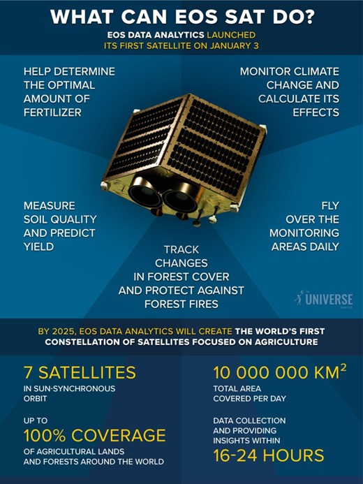
The space industry has made a quantum leap in terms of satellite imaging technology and geospatial data analysis since the first Earth observation missions. Miniaturisation of spacecraft and now-affordable launch costs sparked a boom in private satellite constellation launches. Envisioning the scale of impact and game-changing possibilities they can bring by having their own ‘eyes in the sky’, EOS Data Analytics rode the tide – the company’s first optical satellite EOS SAT-1 reached orbit in January of 2023.
It became the first of seven lightweight satellites within the proprietary EOS SAT constellation, which is expected to reach full operation in the sky by 2025. Dragonfly Aerospace’s optical imaging modules onboard the spacecraft will provide continuous global coverage of farmlands and forestlands, collecting sharp panchromatic and multispectral imagery in 13 agri-related bands. By tailoring the constellation specifically to agricultural needs, EOS Data Analytics aims to address some of the most burning today’s challenges related to food security and depleting natural resources. High-quality data about key crop yield indicators from EOS SAT will enhance the company’s analytics capabilities (including AI-driven geospatial data predictive analytics) and enable the delivery of even deeper and more accurate insights to their agri-clients. Crop health monitoring, disease and pest detection, field productivity analysis, and soil moisture assessment are some of the agricultural applications of EOS SAT imagery envisioned to drive the uptake of precision farming and sustainable practices for the sake of better crop yields and a greener future.
Conclusion
Now is the point where the transformative potential of geospatial data analytics is no longer doubted. EOS Data Analytics is among those who help unlock it and put it to good use, utilising vast scientific and tech expertise and novel AI methods. In the agricultural landscape, satellite data provides farmers with meaningful insights for making precise, informed decisions at every stage of cultivation, thus enabling the implementation of precision farming, and allowing them to grow more with less. EOSDA stands at the forefront of satellite imagery analytics development and provides innovative data-driven solutions that solve the pain points of agriculture, forestry, and other industries in an economically and environmentally sustainable manner.