


Exwayz 3D Mapping can work with any LiDAR and GNSS system on the market, creating centimetre-accurate maps for various applications such as cities, industrial sites, and ports.
The software addresses the technical challenge of generating 3D maps with partially unreliable GNSS data, offering local and global accuracy up to 2cm. It is available in both CLI and GUI formats for seamless integration and is already trusted by major integrators of 3D mapping systems.
The growing need for autonomous mobile robots, projected to reach 100 million annually by 2030, highlights the importance of precise robot positioning. Exwayz 3D Mapping fills the gap between LiDARs and GNSS, providing a solution to the absence of seamless integration between these technologies. The software overcomes the limitations of GNSS in obstructed skies or enclosed spaces and the inability of LiDAR to measure its own position and motion.
According to Hassan Bouchiba, CEO of Exwayz: “Exwayz is committed to revolutionising the robotics landscape by providing state-of-the-art 3D mapping and navigation solutions. Our technology serves as a catalyst, empowering robotics systems across various industries, ensuring precise positioning and unlocking new realms of efficiency and automation.”
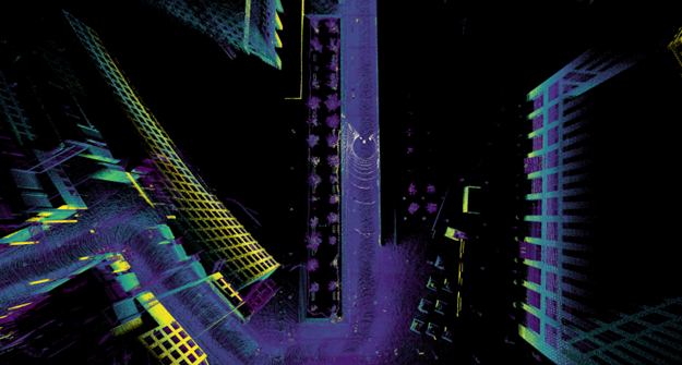
Exwayz 3D Mapping employs cutting-edge algorithms to automatically generate point clouds with 1cm precision. It is an agnostic solution, integrating GNSS and LiDAR of any brand, effectively overcoming previous limitations in creating accurate 3D point clouds.
The software’s applications are vast, including autonomous transport within logistic centres, optimisation of last-mile delivery systems, autonomous shuttles, and autonomous train positioning. Exwayz’s city-scale mapping capability has the potential to revolutionise global transportation systems.
“Our software utilises directly the LiDAR data to generate crystal sharp point clouds, and integrates external GNSS information to ensure global accuracy, without breaking local consistency thanks to our innovative optimisation framework” says Mathias Corsia, CTO of Exwayz. “The software inherently produces flawlessly detailed point clouds devoid of local discrepancies.”
A key feature of Exwayz 3DM is its multi-session SLAM functionality, which enables the fusion of multiple maps from different data collection sessions. This ability to merge data over varying timeframes is ideal for comprehensive map maintenance and large-scale mapping applications. Exwayz 3DM’s innovative approach to map creation offers flexibility and accuracy in mapping extensive urban landscapes.