Modern robotics playing a key role at Chernobyl
The Chernobyl nuclear disaster has hit the news recently. April marked the 33rd anniversary of the catastrophic accident at the Soviet reactor, near the city of Pripyat, in modern day Ukraine, in 1986. In addition, a five-part historical drama starring Jared Harris, Stellan Skarsgård and Emily Watson, is also attracting plenty of viewers on Sky Atlantic.
It would therefore seem apt timing to cover the newly formed National Centre for Nuclear Robotics’ (NCNR) activities in the region which are highlighting the role that modern robotics technology can play in hazardous environments around the globe, and in particular, Chernobyl.
It’s fair to say that you wouldn’t want to spend too long in the area around Chernobyl. Over a quarter of a century after the disaster, some areas of the site still contain extremely dangerous levels of radiation. Therefore, having the ability to use robots (where before the only option would be to send in humans), can significantly reduce the dangers for workers who are sent to the region to conduct tests.
Thirty-three years on Chernobyl is still the world’s worst ever nuclear disaster, substantially worse than Fukushima in 2011, primarily due to the amount of radioactive material that was released into the atmosphere.
The disaster was caused by a steam explosion which started a subsequent fire that released a plume of radioactive material which contaminated a large area of what is now Ukraine and Belarus. When the top of the reactor core was blown off just after midnight on 26th April 1986, the sky immediately above glowed blue due to the radiation flux coming off the core, as it was ionising the nitrogen in the air.
The explosion left a legacy of polluted land which is still one of the most contaminated areas on the planet in relation to radioactivity.
It was the mission of Tom Scott, University of Bristol and Co-Director of the NCNR, and his team to replace human workers in these danger areas and deploy robots instead, in order to test radiation levels and take samples. One such area was the Red Forest, so-called because of the ginger-brown colour of the pine trees after they died following the absorption of high levels of radiation from the explosion. It received a significant amount of the fall-out from the reactor as it is only around 500m from the reactor core itself.
To this day it is the most hazardous area of land in terms of radioactive contamination on the planet. It is not safe for a human to go there as you can receive a year’s dose of radiation in one to two hours.
For the NCNR, this environment offered an ideal opportunity for robotic deployment. Scott commented: “Robots presented us with a method of characterising the distribution of radioactivity in the area. There are trenches in the region where contaminated equipment, such as tractors, fire engines, cranes etc, were buried, and because this was done quite quickly, records on where things were disposed of and where were the highest levels of radioactivity, are incomplete.”
Over the course of a year, the NCNR was invited to make several trips to the region by the Ukrainian Government, to map in detail some of these highly contaminated areas and help understand what is going on.
Scott added: “Back in 1986, robots as we know them today didn’t really exist, and what the authorities had in terms of response capability was men on the ground with handheld radiation detectors, and helicopters which they could send over the fallout zone to make radiation measurements, collect soil samples and to understand what the spread of radiation was.
“That process took many months, many helicopter flights and lots of people getting dangerous doses of radiation.”
Thankfully methods have evolved somewhat since then, with modern robotic technology being employed that simply wasn't even thought of 30 years ago. “We headed to Chernobyl with around £250,000 of equipment,” Scott continued. “We took two fixed wing drones called Titans, which enabled us to fly longer distances, and to cover large areas, flying typically at an altitude of around 45-60m.”
These UAVs allowed the NCNR team to perform what is known as ‘lollipop’ flights. Starting from a safe area, the drone can fly several kilometres into a zone to conduct a survey, and then fly back to the safe area – therefore exposing none of the team to undue amounts of radiation exposure.
When the team found something of interest they would then send a small multi-rotor aircraft over the same area. “These aircraft fly low, slow and if we want them to, we can put them into an aerial park over a point of interest which allows us to get a much better spatial resolution on the ground. They can’t fly as long as the Titans, and therefore we can’t cover such large areas – so we use the two types of drone as complementary tools,” Scott added.
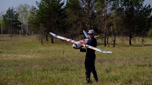
The Titan fixed wing drone
The team also use a novel radiation mapping technology which allows them to achieve high sensitivity for on-the-ground radiation and in real-time – the Autonomous Airborne Radiation Monitoring System (AARM). Scott continued: “This means that from our safe base station (either in the field or back in the UK), we can get a real-time display of the radiation on a satellite underlay. This means that if there was a real nuclear incident we would get data very quickly, which in-turn will allow us to make rapid decisions and allow us to safeguard people’s lives more efficiently.
The work undertaken by the NCNR in the Red Forest constituted the largest ever fixed-wing radiation mapping survey ever conducted, as the technology used for the radiation mapping didn’t exist until the NCNR team built it at the start of this year. Scott added: “We mapped areas of 15km2, flying up to 60km per flight, at relatively low altitude (the lowest safe altitude for a manned aircraft is around 120m, below that is considered too low to be safe – with drones we can go much lower and can therefore achieve greater sensitivity and resolution for your data).”
Product Spotlight
APV1111GVY
Panasonic

Panasonic PhotoMOS® Photovoltaic MOSFET High-Power Drivers
| SKU: | |
|---|---|
| Stock: | 3490 |
| Cost: | $3.95 |