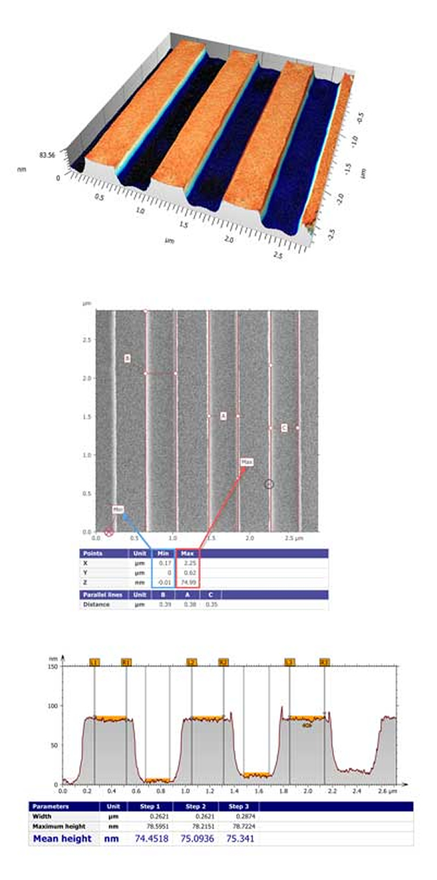
Complete solution for measuring the dimensions of nanoscale patterns
Complete solution for measuring the dimensions of nanoscale patterns introduced by Advantest and Digital Surf. They have announced that PM3D Map software based on Digital Surf’s industry-standard Mountains Technology is now incorporated into the company’s leading-edge Multi Vision Metrology Scanning Electron Microscope (MVM-SEM) series. Advantest’s MVM-SEM system together with PM3D Map software now provide a complete solution for measuring the dimensions of nanoscale patterns on wafers, photomasks and other substrates.
“PM3D Map software is the tool of choice for SEM data analysis and metrology,” stated Advantest. “It will greatly enhance our customers’ experience by offering real-time 3D measurement tools, thus making a significant contribution to improving productivity.”
“We’re excited to bring the world-class Mountains experience to users of Advantest’s SEM metrology systems,” said Christophe Mignot, Digital Surf CEO. Available in 11 different languages 1, ISRA Map software comes with a unique interactive interface for data set preparation, display and analysis. Powerful filters remove outliers and local defects to prepare surfaces for further analysis. Surface roughness and waviness are separated using advanced ISO 16610 filtering techniques, and surface texture is characterised by the latest 3D parameters defined in the ISO 25178 standard, together with ISO 12781 flatness parameters. The new software also provides a generous set of features for surface geometry analysis including measurement of the volume of surface structures (bumps, holes), step heights, contour etc These core ISRA Map features are complemented by numerous optional modules including grains and particles analysis, 3D Fourier and wavelets analysis, statistics and others. Powered by ISRA Map software, based on Digital Surf’s Mountains Technology. The new integrated software features surface imaging, analysis and metrology tools in a smart multi-language user environment, making it possible to produce comprehensive and visual surface metrology reports faster than ever.
Available in 11 different languages, PM3D Map software enables visualisation of 3D topography in real-time, analysis and generation of complete metrological reports. The new software provides a generous set of features for:
- Surface geometry analysis including measurement of the volume of surface structures (bumps, holes), step heights, contours etc.
- Separation of surface roughness and waviness using advanced ISO 16610 filtering techniques.
- Characterisation of surface texture using the latest 3D parameters defined in the ISO 25178 standard.
PM3D Map also offers powerful automation tools to speed up production. The interactive workflow allows full traceability and easy fine-tuning at any point in the measurement process. Data can also be analysed quickly by applying templates or macros. Metrology reports can be exported in standard formats for publication (Excel, PDF and Word-compatible RTF). All images can be output at up to 12dpi for integration into posters and presentations.
Product Spotlight
APV1111GVY
Panasonic
Panasonic PhotoMOS® Photovoltaic MOSFET High-Power Drivers
| SKU: | |
|---|---|
| Stock: | 3490 |
| Cost: | $3.95 |